
LAST UPDATED: October 1, 2025 at 8:30 AM EST
Hurricane Humberto has moved away from threatening any land areas, but the National Hurricane Center continues to issue warnings for East Coast residents and beachgoers about potentially dangerous ocean swells and life-threatening rip currents expected throughout this week.
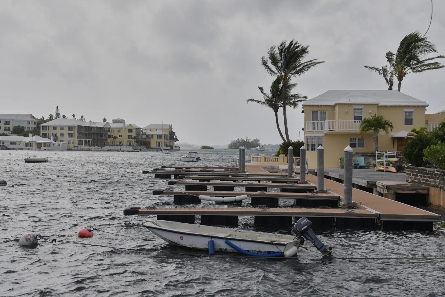
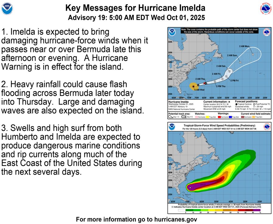
Meanwhile, Hurricane Imelda is taking center stage as the immediate threat, with forecasters predicting it will pass directly over or extremely close to Bermuda later today. The island territory remains under an active hurricane warning as authorities prepare residents for powerful hurricane-force winds, hazardous wave conditions, and significant flash flooding risks that could persist through Thursday afternoon.
Imelda Expected to Strengthen to Category 2
Meteorologists tracking Hurricane Imelda report that the storm is anticipated to intensify to Category 2 status by the time it reaches Bermuda. Current measurements show maximum sustained winds hitting 90 mph, with hurricane-force winds radiating outward approximately 60 miles from the storm’s center. The reach of tropical-storm-force winds extends even further—up to 230 miles from Imelda’s core, creating a massive zone of potentially dangerous weather conditions.
Major Travel Disruptions Across the Region
The approaching hurricane has already triggered widespread travel chaos throughout Bermuda and surrounding areas. Flight tracking service FlightAware reports that approximately 40 percent of both departures and arrivals at Bermuda’s airport have been canceled today, with additional cancellations expected as the storm intensifies. Aviation experts anticipate that delays and cancellations will ripple throughout Caribbean destinations as airlines adjust schedules to ensure passenger safety.
Cruise industry operators are also responding proactively to the weather threat. Multiple cruise lines have announced itinerary modifications, repositioning vessels away from the storm’s projected path to keep passengers and crew out of harm’s way. These route changes may affect scheduled port stops in Bermuda and nearby destinations over the coming days.
Traveler Advisory and Safety Recommendations
Anyone with travel plans involving Bermuda, the Bahamas, the Caribbean, or along the U.S. East Coast should immediately contact their airlines, cruise operators, or tour companies to verify their travel status. Weather conditions remain fluid, and transportation providers are continuously updating their operations based on the latest forecasts from the National Hurricane Center.
PREVIOUS UPDATE: September 30, 2025, at 8:30 AM EST
Hurricane Humberto no longer poses a direct threat to populated areas, though the National Hurricane Center continues advising residents and visitors in Bermuda, the Bahamas, the northern Caribbean islands, and along the U.S. East Coast to remain vigilant regarding dangerous rip currents and ocean swells throughout the week.
Current tracking shows Humberto moving on a path that will take it west, then northward past Bermuda today and Wednesday, traveling parallel to the Eastern Seaboard without making landfall.
Tropical Storm Imelda has since strengthened into a hurricane. Bermuda currently maintains a hurricane watch that meteorologists expect to escalate to a full hurricane warning. The storm is moving away from the Bahamas today based on latest projections and will approach Bermuda by late Wednesday.
Coastal communities along the East Coast extending down to North Carolina are bracing for heavy rainfall totals reaching up to four inches this week. Storm surge predictions indicate some Florida coastal areas could experience water level increases between one and two feet.
Flight disruptions have already begun, with FlightAware documenting eight canceled flights at Bermuda International Airport this morning alone due to Hurricane Imelda’s impact on routes connecting Bermuda and the Bahamas.
Travelers throughout the affected regions should maintain close contact with their airlines and monitor evolving weather conditions throughout the week. Cruise operators continue repositioning ships away from the storm’s anticipated path.
INITIAL REPORT: September 29, 2025
The eastern American seaboard, Bahamas, and Bermuda are preparing for impacts from two significant weather systems this week: Hurricane Humberto and Tropical Storm Imelda.
According to National Hurricane Center data, Category 4 Hurricane Humberto will generate dangerous surf conditions stretching from Bermuda across the entire eastern U.S. coastline this week, with tropical storm conditions forecast for Bermuda on Tuesday.
Hurricane Humberto is tracking northwest at 14 mph, packing maximum sustained winds of 145 mph. Hurricane-force winds extend 60 miles outward from the storm’s center.
Although Humberto isn’t expected to make landfall, residents and travelers within the eastern coastal corridor should consult local weather authorities for updates, as warnings regarding powerful rip currents and dangerous swells remain in effect.
“Swells generated by Humberto will continue to affect portions of the northern Leeward Islands, the Virgin Islands, Puerto Rico, and Bermuda through much of this week,” the latest NHC advisory stated. “Swells from Humberto will also affect the U.S. East Coast beginning today. These swells are likely to cause life-threatening surf and rip current conditions.”
Tropical Storm Imelda is currently producing tropical storm conditions across the northwest Bahamas this morning. Active warnings cover the region, including Eleuthera, the Abacos, and Grand Bahama Island. Forecasters predict Imelda may achieve hurricane status by Tuesday, September 30.
The storm is advancing north at 9 mph with current maximum sustained winds measuring 50 mph. Tropical-storm-force winds reach outward up to 175 miles from Imelda’s center.
Weather forecasters indicate that Imelda will curve sharply northward, passing offshore of the U.S. coastline without making landfall. However, the NHC warns about concerning swells, flooding potential, and storm surge threats spanning from the Caribbean to North Carolina through Tuesday. Coastal storm surge could rise as high as three feet in certain areas.
“Storm total rainfall amounts of 1 to 2 inches with local maxima of 4 inches are expected through Tuesday across northeast Florida, coastal South Carolina, and coastal sections of southeast North Carolina,” the advisory explained. “This rainfall could result in isolated flash and urban flooding.”
Travel Industry Response
Travel companies are treating both weather events with serious concern. Major cruise lines have rerouted previously scheduled stops to the Bahamas and Bermuda scheduled for this week.
Carnival Cruise Line, for instance, has repositioned eight vessels operating in the Caribbean and along the East Coast route to the Bahamas and Bermuda, modifying itineraries to circumvent severe weather. Passengers booked on affected cruises will receive direct notification from their cruise line regarding any itinerary adjustments.
FlightAware data shows flight cancellations and delays affecting airports in Bridgetown, Grand Bahama, Fort Lauderdale, Providenciales, and additional regional hubs. Travelers heading to these destinations should stay current with airline communications and local weather updates. Additional delays and cancellations are anticipated through Wednesday.
Stay informed about weather-related travel disruptions, destination updates, and trip planning guidance at The Inspiring Insight—your go-to source for timely travel news and expert advice to help you navigate unexpected changes to your vacation plans.